by Alison Mitchell, Co-Executive Director, New Jersey Conservation Foundation
New Jersey’s largest protected property, Wharton State Forest in the Pine Barrens, covers 195 square miles in Atlantic, Burlington and Camden counties. For perspective, it’s bigger than the entire land mass of Hudson County! Wharton is crossed by hundreds of miles of avenues used by motor vehicles, everything from highways to unpaved sand roads to single-track dirt bike trails.
For decades, these avenues have been used – and sometimes abused – by visitors. The majority of drivers responsibly use street legal vehicles to explore legitimately in the forest, visiting hiking trails, campgrounds, canoe launches, ghost towns like Martha, and scenic or historic sites like Quaker Bridge and Carranza Memorial.
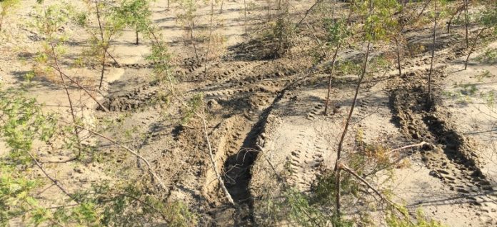
But a destructive minority have been tearing around in illegal off-road vehicles (ORVs) or in powerful registered four-wheel drive trucks, recklessly damaging wetlands, streams, rare plants – some found only in the Pine Barrens – and habitats for endangered and threatened wildlife. The scars and damage left by these irresponsible riders take decades to heal, and some of the damage is irreparable.
Things are about to change for the better at Wharton!
After nearly three years of studies and public surveys, the New Jersey Department of Environmental Protection (DEP) has rolled out a proposed “Visiting Vehicle Use Map” designating legal motor vehicle routes within Wharton State Forest. The idea is to protect ecologically sensitive areas while preserving reasonable public access to the forest.
Under the proposed map, 200 miles of roads would remain as legal driving routes for visiting vehicles. Another 200 miles would be placed off-limits because of their proximity to imperiled animal species, wetlands, historic resources, rare plants and ecological habitats. Studies found that an additional 100 miles had been “misidentified” as roads on older maps, since they were either created illegally or originally intended as fire breaks and farm access lanes.
The new map is a highly encouraging sign that the DEP is serious about protecting Wharton’s ecological integrity and status as New Jersey’s flagship state forest.
Having a clearly-drawn map of Wharton’s publicly accessible roads should help State Park Police better patrol the forest for illegal off-road vehicle use and issue citations where appropriate.
And effective law enforcement is an essential piece in ensuring Wharton State Forest has the protection it needs. Though the map will help law-abiding citizens avoid inappropriate motorized uses, there remains a very determined and sizable group of rogue motorized vehicle users throughout New Jersey, and especially in the Pine Barrens, who are unlikely to stop their destructive activities until they are cited and fined.
There must be a strong commitment by law enforcement leadership, as well as increases in staff patrols in the forest. Without both of these measures, it will be nearly impossible to thwart illegal riders.
Even before the new Wharton map was proposed, “off-roading” (literally leaving road surfaces) has been prohibited on all state-owned lands. Illegal ORVs include all-terrain vehicles like quads, non-street-legal utility terrain vehicles also known as side-by-sides, unregistered dirt bikes and non-street-legal vehicles with oversized tires, like monster trucks.
Under the law, vehicles in state parks, forests and wildlife management areas must be street legal, registered, plated, insured, and operated by a licensed driver on an established road.
In 2021, the State Attorney General’s Office was successful in increasing fines for illegal off-road vehicle use and damages. Fines now start at $250 to $500 for a first offense, $500 to $1,000 for a second offense, and a minimum of $1,000 for a third or subsequent offense. If a violation results in damage to or destruction of natural resources, an additional fine of five times the cost of the damage may be assessed. Of course, violators have to be apprehended and cited in order for any of this to have its intended effect.
Many tools are already in place, and now one more will soon be added: the official Wharton State Forest Visiting Vehicle Use Map
The DEP is now accepting online comments from the public for the proposed Wharton map, through Saturday, March 9. The public comment period is a great opportunity for those who love Wharton State Forest to speak out in favor of stronger protections for this New Jersey gem.
Wharton State Forest is an amazing place, home to some 300 bird species, nearly 60 reptile and amphibian species, and more than 90 fish species. Forty-three are listed by the state as threatened or endangered, including bobcats, timber rattlesnakes and red-headed woodpeckers. Wharton also has some 850 plant species, including rarities like bog asphodels, curly-grass ferns and Pine Barrens gentians.
Please let the DEP know that you want Wharton’s rare species and special places protected, and that the best way to do it is by designating legal public routes and stringently enforcing the law!
The DEP has set up an excellent website on the proposed Wharton State Forest visiting vehicle use map at https://www.nj.gov/dep/parksandforests/wharton/?utm_medium=email&utm_source=govdelivery#data. It includes maps of Wharton, frequently asked questions, and a public comments form at the bottom of the page. Please speak out in support of this long-needed tool.
And for more information on preserving New Jersey’s land and natural resources, visit the New Jersey Conservation Foundation website at www.njconservation.org or contact me at [email protected].


